LAND SURVEYS
Whether you are a housing developer, civil engineer, architect, farmer or private land owner requiring a topographic survey for planning permission, Invar Mapping Surveys has the right service for you.
When considering any form of change to any specific piece of land or property, the first step is to provide a high quality, accurate, up to date plan of the area. This is called a Topographical (topographic or topo) survey. These plans must be accurate, showing every piece of detail to a specific scale. The survey must then be presented in a form that is easily understood by the client. Topographical surveys are the main base of expertise for Invar Mapping Surveys and for 40 years now has provided highly accurate, quality and professional surveys for its client base.
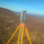
Using the latest cutting-edge robotic Trimble total stations and Trimble GNSS system; we ensure our work meets expectations and deadlines. Field data is collected and processed back in the office using a combination of our dedicated surveying software and AutoCAD. You will then receive a digital copy of our survey in which you can take on the next step with planning permission, building or planning the layout for a house etc. No matter how small or large the area is, we can survey it, for a very competitive price.
Digital Data
All our surveys are produced using specialist surveying software and finalised in AutoCAD to a very high standard. Formatting for layering, colours, line types etc. can easily be accommodated. Your survey data can be emailed or supplied on CD/DVD.
Digital data format include:-
-
DWG
-
DXF
-
PDF
-
Other
Hard Copies
Plots can be provided to your required scale and plot size, on to quality paper or polyester film, in black and white or full colour. Our paper sizes range from A4 to A0.